
INDIAN ARMED FORCES CHIEFS ON
OUR RELENTLESS AND FOCUSED PUBLISHING EFFORTS

SP Guide Publications puts forth a well compiled articulation of issues, pursuits and accomplishments of the Indian Army, over the years
I am confident that SP Guide Publications would continue to inform, inspire and influence.

My compliments to SP Guide Publications for informative and credible reportage on contemporary aerospace issues over the past six decades.
Indigenous GPS What it means
 |
By Lt. General P.C. Katoch Former Director General of Information Systems, Indian Army |
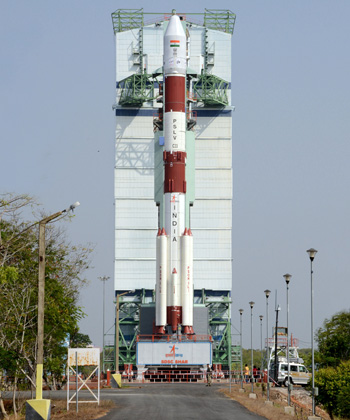
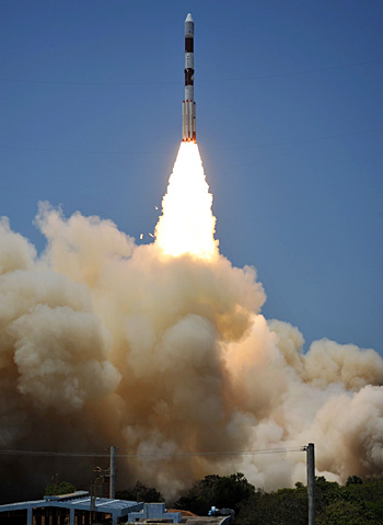

Prime Minister Narendra Modi, along with many awed Indians, watched the successful launch of ISRO’s PSLV-C33 Satellite Launch Vehicle lift of successfully from Sriharkota at 12.50 pm on April 28, placing the satellite IRNSS-1G in orbit some 20 minutes after liftoff. IRNSS signified ‘Indian Regional Satellite System’. The first satellite of the series, IRNSS-1A was launched in July 2013. Two more satellites were launched during 2014. In January and March this year, ISRO placed the fifth and sixth satellite of the series in space (IRNSS-1E and IRNSS-1-F).
IRNSS-1G being the seventh and final satellite, the seven satellite system which will be operational in two months from now, will provide India with its indigenous Global Positioning System (GPS), termed NAVIC, which can be used both in the military and civilian fields. With NAVIC (short for Navigation with Indian Constellation), India joins the exclusive club of nations having their own GPS, others with operational systems being the US (GPS), Russia (GLONASS), France (Doris) and China (BDS). The satellite systems of US, Russia, France and China have between 28 to 35 satellites because they have been developed for global coverage. India’s NAVIC has seven satellites since it has been developed for regional coverage, which can always be expanded later, as required. It will cover a radius of 1500kms with India as the centre. NAVIC is another remarkable achievement of ISRO that has made the nation proud. Congratulating ISRO on this milestone, PM Modi said, “We used to be dependent on others for navigation, today we have become independent”, adding, “The new technology will not only benefit our people, our fishermen, but can also help the SAARC nations”. Pakistan of course being fully under the Chinese shadow has said that she is not interested in NAVIC. With PLA already deployed in POK-Pakistan and China raising three additional Divisions for protecting the CPEC, Pakistan would naturally bid for China’s BDS.
From the military viewpoint, having an indigenous is vital because without this, the service provider can feed wrong information anytime, particularly during critical time in during operations. Alternatively, the GPS can even be switched off by the service provider, under guise of technical fault or even otherwise, which can be disastrous particularly for naval ships and vessels on the high seas. Additionally, encrypted precision is around 0.1 metre (as available to USSF and Spetznaz) but it is expensive and may not be provided by foreign vendor. NAVIC will provide accuracy of about 20 metres compared to 5 metres by America’s GPS or Russia’s GLONASS, but it will certainly reduce dependency on foreign satellite systems within the coverage area of NAVIC. A major task, however, remains in how to provide the NAVIC facilities to the users the public at large, the military and all other security forces. For this, ISRO has developed a coded chipset that can be incorporated with an existing receiver of a smart-phone or any positioning system device on vehicles, ships, helicopters or aircraft to communicate with the satellite for obtaining positioning information.
ISRO has also been conducting meetings with navigation device manufacturers and mobile phone manufacturers to demonstrate how IRNSS could provide accurate information on par with the American GPS. The challenge is not only improving accuracy but also mass produce ISRO’s coded chipsets developed for incorporation in existing receiver. Individual receiver handsets for the military and security forces may have to be produced, if the ISRO developed chipset cannot be incorporated into existing GPS handsets. The overall numbers required, both for civil and military applications, would be gigantic, in millions, considering rising India’s population and the pace of digitization. This would also have to be done seedily considering NAVIC would be operational in next two months. Multiple assembly production lines under ‘Make in India’ would perhaps be the right answer. for the military and security forces, if the chipset cannot be Given the pace at which ISRO is surprising India, and the world, it can perhaps be taken for granted that ISRO would be already working double time to improve the accuracy of NAVIC, especially encrypted precision so vital for military applications. With the PSLV C34 launch slated from Sriharkota next month, injecting an incredible number of 22 satellites (18 for foreign agencies) simultaneously in space from a single rocket, ISRO would herald another great leap. This may be the precursor for NAVIC going global with better precision in a future timeframe.
Photo Credit: ISRO, PIB
SP's Aviation - Current Issue