
INDIAN ARMED FORCES CHIEFS ON
OUR RELENTLESS AND FOCUSED PUBLISHING EFFORTS

SP Guide Publications puts forth a well compiled articulation of issues, pursuits and accomplishments of the Indian Army, over the years
I am confident that SP Guide Publications would continue to inform, inspire and influence.

My compliments to SP Guide Publications for informative and credible reportage on contemporary aerospace issues over the past six decades.
India Joins Elite Space Club
India joins top satellite club such as the US, Russia, China and Europe which all have their own satellite navigation systems
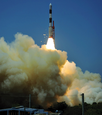
On April 28, 2016, India launched the seventh and final satellite to create its own satellite navigation system to be known as NAVIC or Navigation with Indian Constellation, thus joining an elite group of nations having their own satellite navigation systems. The United States has NAVSTAR global positioning system (GPS), Russia has GLONASS, the European Union has Galileo and China will have BeiDou by 2020.
The Indian system–previously called the Indian Regional Navigation Satellite System (IRNSS)–was designed to provide accurate position information to users in India and as far as 1,500 kilometres (932 miles) from its borders. The satellites will be able to track the location and position of vehicles, provide information during natural disasters and integrated with mobile phones for navigation and other location services. It will provide two kinds of services: one which is open source and another which is restricted and strongly encrypted, provided only to “authorised users,” according to Indian Space Research Organisation (ISRO).
Prime Minister hails scientists
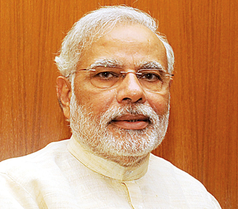
Prime Minister Narendra Modi in his Twitter account said: “With this successful launch, we will determine our own paths powered by our technology. This is a great gift to people from scientists.” He also said: “Our efforts will not only help India but we can help fellow SAARC nations as well.”The President of India, Pranab Mukherjee, said the launch of the satellite was “an important landmark in our space programme with India now joining the small group of nations having their own regional satellite navigation system.” The launch “demonstrates, yet again, India’s growing capabilities in space launch technology.”
WE ARE NOW ONE OF 5 COUNTRIES WITH OUR OWN NAVIGATIONAL SYSTEM. TODAY WE ARE FREE OF DEPENDENCE ON OTHER COUNTRIES FOR NAVIGATION. OUR PLANES WILL BE ABLE TO LAND WITH EASE AND ACCURACY, WE CAN PLAN DISASTER RELIEF BETTER AND WITH OUR OWN TECHNOLOGY.
— NARENDRA MODI, PRIME MINISTER OF INDIA
Final satellite of IRNS 1G
The seventh and final satellite of the Indian Regional Navigation Satellite System, the IRNSS-1G, was launched into a subgeosynchronous transfer orbit with a perigree (nearest point to earth) of 284 km and an apogee (farthest point to earth) of 20,657 km. The satellite was launched on board the polar satellite launch vehicle (PSLV), which took off from the Sriharikota launch pad on April 28.
ISRO said that with this launch, the IRNSS constellation of seven satellites is now complete. This will allow ISRO to focus on the process of designing frontend chips which will receive the navigational signals sent out by the satellites. The system will be similar to the global positioning system (GPS) operated by the United States with 24 satellites and the GLONASS, Galileo and BeiDou systems of Russia, Europe and China respectively.
An area of 1,500 km from Indian boundaries will be covered under the navigational system. The Prime Minister invited other countries to make use of this system as well. “We have seven neighbours who rely on technology provided by other countries. They can use Indian services if they want,” he said in a video message addressed to ISRO engineers. The Prime Minister appreciated India’s space community for making the country proud through such achievements which have helped in improving the life of common man.
Aircraft can land with ease and accuracy
With an accuracy of better than 20 m being claimed by ISRO, the navigation system will be offered as an open or Standard Positioning Service and a superior, coded military Restricted Service. “We are now one of five countries with our own navigational system. Today we are free of dependence on other countries for navigation. Our planes will be able to land with ease and accuracy, we can plan disaster relief better and with our own technology,” the Prime Minister said.
WITH AN ACCURACY OF BETTER THAN 20 M BEING CLAIMED BY ISRO, THE NAVIGATION SYSTEM WILL BE OFFERED AS AN OPEN OR STANDARD POSITIONING SERVICE AND A SUPERIOR, CODED MILITARY RESTRICTED SERVICE
Explaining the name NAVIC, Modi said the system was dedicated to India’s mariners and fishermen who have been navigating using the sun and stars as waypoints for hundreds of years. “They have shown strength and determination in venturing out to sea for so many years. We have named this system for them, the ‘Naviks’ (mariners).”
Constellation of satellites
IRNSS-1G is the last of the seven satellites constituting the space segment of the IRNSS. IRNSS-1A, 1B, 1C, ID, IE and 1F, the first six satellites of the constellation, were successfully launched by PSLV on July 2, 2013, April 4, 2014, October 16, 2014, March 28, 2015, January 20, 2016 and March 10, 2016, respectively. All the six satellites are functioning satisfactorily from their designated orbital positions.
IRNSS is an independent regional navigation satellite system designed to provide position information in the Indian region and 1,500 km around the Indian mainland. IRNSS provides two types of services, namely, Standard Positioning Services (SPS) — provided to all users and Restricted Services (RS) — provided to authorised users. A number of ground facilities responsible for satellite ranging and monitoring, generation and transmission of navigation parameters, etc., have been established in 18 locations across the country.
The Minister for the Department of Space, Jitendra Singh, said that the country also plans to launch a communications satellite that will provide enhanced bandwidth connectivity to rural areas. The satellite will be launched towards the end of 2016 or the first quarter of 2017. ISRO plans to launch 22 satellites in another flight of PSLV including 19 satellites from four countries: 13 from the US, three from Germany, two from Canada and one from Indonesia.
SP's Aviation - Current Issue